Mapping Police Violence
  • Police Violence Map
  • Cities Compare States
  • National Trends
  • Police Scorecard
  • Year-End Police Violence Report
  • About the Data
  • Planning Team

Mapping Police Violence

  • Police Violence Map/
  • Compare Places/
    • Cities
    • Compare States
  • National Trends/
  • Police Scorecard/
  • Year-End Police Violence Report/
  • About the Data/
  • Planning Team/

Mapping Police Violence

Mapping Police Violence is a research collaborative collecting comprehensive data on police killings nationwide to quantify the impact of police violence in communities.

National Trends

Mapping Police Violence

  • Police Violence Map/
  • Compare Places/
    • Cities
    • Compare States
  • National Trends/
  • Police Scorecard/
  • Year-End Police Violence Report/
  • About the Data/
  • Planning Team/

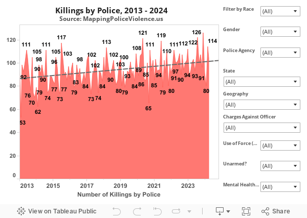
The data presented below shows national trends in police killings from 2013 to 2024. This information can be used to monitor trends in police killings over time to determine whether the United States is making progress towards ending this violence in our communities.